Whilst playing around with Google Maps earlier this week, I
found Mount Hebo view point, which is less than 81 miles from
our home. It seemed like a good destination for a long day trip
by motorcycle - it's right on the border of Tillamook County and
Yamhill County - two of our very favorite counties in Oregon for
motorcycle riding. So I did some more looking around online and
found National Forest Service Road 14 (NF-14 - also known as
National Forest Development Road 14 and road 1400) from Bible
Creek Road. It looked like the road went right up to the view
point, and though I couldn't find any reviews for the road
anywhere online, I surmised it would be doable by motorcycle
since Mt. Hebo used to be a military base. Still, I was worried:
we have been on Bible Creek Road
many times, going from
Nestucca River Road to Willamina (GREAT little restaurant there
at the Wildwood Hotel), but we've never seen a sign for a forest
road - in fact, I hadn't even known that was
Siuslaw
National Forest (I always thought the whole area was
Tillamook State Forest). Also, in national forests, NF roads are
marked with a brown street sign with the road number on it, but
we'd never seen such in our many times in that area.
Let's
jump to the chase for those looking to ride NF-14 to or from Mt.
Hebo: yes, it's doable by dual sport motorcycle (not just a dirt
bike).
Stefan was on his vintage Honda Africa Twin
(from the family of models never sold in the USA) and I was
on my KLR. In fact, the first half of the
gravel road, going West, is good enough for a car for the first
nine miles (not only a four-wheel drive vehicle). It's way, way
easier going up it, from Bible Creek Road, than going down it
from Mount Hebo. It's an excellent gravel road - at least it was
on July 1, 2018 - except for the half mile or more before the
mountain, which is dirt and large rocks and very steep - I
cannot imagine doing that part of the road when it's wet and I
cannot imagine doing it without having taken
an off-road riding course earlier this year.
The first nine miles are very easy - easier than Dixie Mountain
between Scappoose and North Plains. Then, after that part, it is
TOUGH. Be ready to stand on your bike for that - and, perhaps,
the entire thing.
Note: the road, as it gets closer to Mt. Hebo, is impassable
in the winter because of snow. I wouldn't ride any of this until
the rains stop in the PDX area (usually in late June) - there
will be a LOT of mud in the last 5-9 miles of this road, getting
closer to Mt. Hebo.
There is no sign for the start of NF-14 from Bible Creek
Road. It's 18 miles from the turnoff of Bible Creek Road to the
Mt. Hebo viewpoint, and it took me 90 minutes to do that 18
miles - it would take someone who is an excellent rider probably
40 minutes. From Forest Grove, Oregon to Mt. Hebo and back was
161 miles total, and with our stops for rests, lunch, photos and
ice-cream, plus 30 minutes backtracking because of a closed
road, it took us 6.5 hours. For a better adventure rider on
NF-14 going faster and taking no pauses, and taking out the
detour on Nestucca, this entire day trip would take an hour -
two hours less than me. If you are coming from Portland, budget
your time accordingly.
The start of NF-14 is 3.7 miles from the junction of Nestucca
River Road and Bible Creek Road, or less than 1.4 miles from the
junction of SW Bald Mountain Road and Bible Creek Road, or 13
miles all the way from Willamina.
Before I begin my in-depth ride report, let me remind everyone
that I'm not Little Miss ADVRider by any stretch of the
imagination. Standing for hours and hours while navigating
treacherous terrain just to say, completely exhausted, "Wahoo,
look what I did!" is not my idea of fun. That said, I
love
visiting ghost towns and beautiful vistas, and camping in remote
areas, and all of those are reached by gravel roads. As I've
told
Stefan many times, as long as there is a great payoff and
long rest at the end, and he's patient with me, I'm up for most
gravel road rides. I'm so proud to have ridden state road 279 to
142 in Moab, Utah - part of it is also known as
Potash Road. It would have been my
greatest triumph as a motorcycle rider had it not been for
my crash on Shaffer Switchbacks. And I'm
so proud that, two years later, I took
the back road from Jordan Valley, Oregon into
Silver City, Idaho - I still get looks of awe from people
who know what that 25 miles of road is like (the main road is
all gravel too, but MUCH easier). Heck, I'm in awe that I rode
my motorcycle
down into the Dungeness Forks Campground
in Olympic National Forest. But none of these roads would have
been worth it just to do the roads - I was looking for a payoff
at the end: a gorgeous vista or a ghost town or a campground. 30
miles of really difficult dirt and gravel road is my limit for a
day. I say all this because "real" ADV Riders balk at my road
descriptions (and that I dare to even ride a KLR). If that's you
- just stop reading now, because the following won't be your
experience at all.
Ride report:
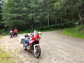
We left our home at 9:30 in the morning. I wanted to ride
NF-14 from Bible Creek Road because I knew that would be mostly
a ride up, and I do MUCH better on gravel when I'm going up. We
took 47 through Gaston, Yamhill and Carlton, a ride we've done
oh-so-many times, and then headed onto Nestucca River Road. We
had taken that road all the way from Bible Creek Road just the
week before, but this weekend, it was closed just after the Fan
Creek Campground, so we had to head back the way we came a few
miles and take Bald Mountain Road and then Bible Creek Road. As
I noted earlier, there is no sign for the start of NF-14 from
Bible Creek Road. Immediately after making the turn on NF-14,
you come to a fork in the road. When we were there, there was
a brown road sign at the fork that said
"Falls." We had no idea what that meant. I hope it wasn't
a warning to motorcycle riders. Stefan's GPS said to go to the
right, so that's what we did. After 3.5 miles, we came to
another fork, which had a sign - to the right, 1.5 miles, was
something called Niagra Falls, and to the left, 9 miles, was a
lake. Later, I read that
the Oregon version of Niagra Falls is actually
quite lovely - we will visit some other time. Had we gone
right, we would have ended up on National Forest Service Road
8533, and that after 8.5 miles would have taken us back out to
Nestucca River Road (so you could make the ride we did five
miles longer if you started from NF-8533, plus, see Niagra Falls
if you have time to hike).
We went left at the aforementioned junction to continue on
NF-14 toward Mt. Hebo and, for the next 9 miles, the road was
fine for me - some potholes, but, otherwise, no hairpin turns,
no severe inclines or declines, no dramatic drop offs. It was an
all around very pleasant ride, and I was once again so happy I'd
taken an off-road riding class - I really enjoy standing up
while riding except for being out of shape and needing to sit
down and take a break every so often. We noticed a few good
places for rough camping! The road for 9 miles would be
absolutely passable by our little Honda Fit.
We stopped after about 9 miles at a big, flat turnoff on the
right where the gravel to service the road is stored. It's such
a big mound, and has been there so long, that grass and small
trees are growing on top of it. Behind it is a beautiful sheer
cliff and fantastic rough camping spot. In front of it,
unfortunately, is a spot where people with guns shoot targets. I
HATE people that practice shoot on public lands in areas not
formally designated for such. They ruin the natural sounds and
solitude with the noise, they leave crap everywhere (clean up
after yourselves, assholes), and they shoot road sides, making
them unreadable - and we really need those signs when we're in
the wilderness. Luckily, that day, there were no assholes with
guns, so we were able to enjoy the peace and beauty. At one
point, I lost sight of Stefan and, because of the cliff, had a
Picnic
at Hanging Rock moment - that was creepy. Otherwise, great
place to stop, and I needed to stop - I was exhausted.
I was thrilled that we had met no cars at all on the road, and
none had been behind us. I was also thrilled at how manageable
the road had been up to this point, 9 miles in. But I also knew
the road was going to eventually start going up and not stop
until the top of Mount Hebo. And the road looked like that
incline was going to start right after this rest stop. And I was
right: up it went. Up and up and up, and became more challenging
with steeper inclines and shorter terms.
12.5 miles in, we came to another junction. To the left was
NF-1428, and this leads to a lake and an official National
Forest campground:
South Lake Dispersed Area. I would love to
camp there sometime, via motorcycle - but the thought of doing
this road loaded down with full panniers kinda freaks me out...
plus, I would hate it if the campground turned out to be full of
a bunch of let's-shoot-stuff-for-fun gun nuts.
We paused at that junction in the road, just for a couple of
minutes, before continuing on NF-14, and after that junction,
things get crazy steep on the road, there's much more dirt and
big rocks, and there is NO where to stop or pull over. We met an
SUV coming down and I was so glad it came where it did, because
had it been anywhere else, before or after, there was no where
for him to get over and there was no where or no way for me to
stop on such a steep incline. Also, the road was becoming more
dirt than gravel and I was starting to think we were no longer
on NF-14. I powered right by the SUV, probably with a look of
terror on my face. About 14.5 miles into the NF-14 ride, we
finally completed the worst part of the road, and came to
another junction and a flat part. I was SO happy I'd chosen to
do this road from the West, because there is NO WAY I could have
done those last nine miles to the East, downhill, on such a
steep road. This junction felt like the summit: to the right was
a wooden fence along a bit of paved road and, to the left, was
gravel. I thought we were supposed to go right, but we weren't
sure, because shrubbery blocked our view, so rode Stefan on
without me - he wasn't gone 30 seconds before he came back and
said he'd come to a gate and there was no more road on the other
side. Later, I learned that that's a rarely used access road to
the tower for radio station KTIL FM.
We went left and could see that this part of the road was a once
frequently-used gravel road, with cement barriers crumbling on
the side. I got a
flashback to Chornobyl (Chernobyl) and
Ukraine. Warning if you are riding this: stay in the middle of
the road, because there are a couple of motorcycle-swallowing
holes near those crumbling barriers. We came to an open area
with plenty of wide parking on the grass on either side of the
road and a guy was parked there with his kids. Was this the top?
The view point? I wasn't sure, so I kept riding. About 17 miles
up from Bible Creek Road (my speedometer calculation said 18),
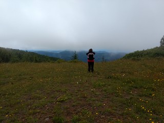
we finally came to the Mount Hebo Viewpoint - it's to the right
of the road from this direction, behind you as the paved road
appears in front of you, and VERY easy to miss because it's
behind you as you summit from NF-14.
The site you see here -
all of the cell phone towers - is not the
spot where the Mount Hebo radar array stood - that's out on
the lookout you see beyond the information
sign. The radars were serviced by the Mt. Hebo Air Forest
Station (AFS) once upon a time. Apparently, it's usually cloudy
and foggy on Mt. Hebo in summer, and it was the day we visited,
though we did get some breaks in the fog for some ocean views.
If you go, try to stay for a full hour, so you might get
some breaks in the fog as well. Even
fogged in, it's a neat site - a piece of Cold War history. For
the second time, I got a flashback to my time in Ukraine. It
felt so similar.
We
ate the lunch we brought (egg and cheese sandwiches, canned
pineapple, and nut bars) and were thankful when the guy in the
pickup who was running his engine in order to stay warm decided
to leave. And then the other family in the other pickup truck
left - the driver burped a lot.
We had the entire site to ourselves for an
hour or more. It's a nice, easy hike out to the site of
the radar array and back.
After exploring the area, we got back on the bikes and headed
down the paved, winding road to state road 22 - less than 8
miles and very beautiful. Unfortunately, we missed the former
site of the actual Mt. Hebo Air Force Base - if there was a
sign, we missed it. In fact, all the signs on the road are
facing people coming up the road, not people going down. We did
see the back of the sign for Hebo Lake Campground.
Then we headed South on State Road 22, also called the Three
Rivers Highway. It's really beautiful, but I think a lot of
motorcyclists miss it because they are so focused on the
over-rated 101. Had I been less tired, I would have stopped at
Fort Yamhill State Heritage Area along the
way - we've never been. But we pushed on to Willamina, both in
need of a sugary snack to get us all the way home. We stopped
for gas in McMinnville and then were back at our house at 4:20
in the afternoon, greeting a very hungry Lucinda the dog who was
quite frustrated to have been left behind.
And now this word from my husband:
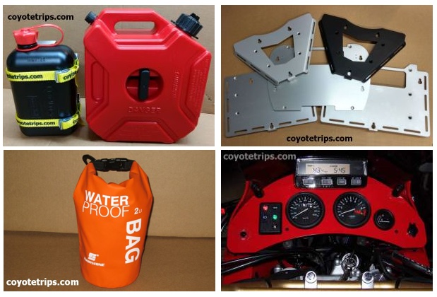

Adventure Motorcycle Luggage
& Accessories
www.coyotetrips.com
Tough, Durable Motorcycle Fuel Containers in two
different sizes,
Top Case Adapter Plates,
Facet Fuel Pump with & without holder (for Honda XRV750
Africa Twin, holder fits RD07 & RD07A only),
& Much More (check coyotetrips.com
frequently for latest offerings - they change!).
Designed or Curated by an experienced adventure motorcycle
world traveler
Based in Oregon. The designer & curator doesn't just sell
these items - they are what he uses himself (& me, his
wife). Nothing here hasn't been FULLY tested by the designer
himself.
You won't find these exact products anywhere else;
these are available only from Coyotetrips.
Comments are welcomed, and
motivate me to keep writing -- without comments, I start to think
I'm talking to cyberair.