Part 5: Two Weeks in Idaho
(mostly): a Motorcycle Adventure
September 2016
DRAFT
Introduction and Part 1 (Hell's Canyon
drive from Oxbow Bridge along the Snake River to the Hell's Canyon
dam and then back over Oxbow dam to Cambridge, Idaho, and everything
up to Part 2)
Part 2: Silver City, Idaho
Part 3: Bruneau Dunes State Park, City of
Rocks National Reserve, Sawtooth Scenic Byway, Sun Valley and
Ketchum
Part 4: Custer, Idaho
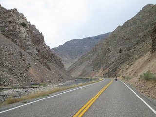
Friday, Day 8
Back on state Road 75, after a fantastic visit to Custer, Idaho, heading from Sunbeam to
Challis. And I kept hearing Kurt Cobain in my head, singing "Jesus
don't want me for a sunbeam..."
We were 8 days into the trip. We were more than half done, and we'd
already seen and done SO much. Wow.
We weren't sure where we would end up for the night - but we rarely
are. We didn't think we could make it to Missoula, Montana that same
day. Heck, we didn't think we could make the Montana border that
day. We saw the sign for Bayhorse
and the Land of Yankee Fork state park, but it was so early in
the trip, we didn't stop. After checking the interwebs after we got
back, I'm glad we didn't - there's not nearly as much to see there
as there was back in Custer.
 The
road was really lovely until the connection with 95. It's not that
it got ugly, but just not as beautiful as it had been. It was was
threatening rain and had cooled off quite a bit - and was getting
colder. We stopped for lunch in Challis, I got biscuits and gravy
again (all day breakfast! Wahoo!), and we chatted with the super
friendly waitress. We also encountered a super snobby biker.
Motorcyclists tend to be friendly people, eager to share information
about weather and road conditions. Not this one. I asked her if she
came from rain and she just looked annoyed at me and said no, then
went to her table and buried her head in the menu. Okay. To make
matters worse, when she walked outside, Stefan was moving my bike
for me - I'd parked in a weird way - and she freakin' SMIRKED AT ME.
Screw you and your BMW, asshole.
The
road was really lovely until the connection with 95. It's not that
it got ugly, but just not as beautiful as it had been. It was was
threatening rain and had cooled off quite a bit - and was getting
colder. We stopped for lunch in Challis, I got biscuits and gravy
again (all day breakfast! Wahoo!), and we chatted with the super
friendly waitress. We also encountered a super snobby biker.
Motorcyclists tend to be friendly people, eager to share information
about weather and road conditions. Not this one. I asked her if she
came from rain and she just looked annoyed at me and said no, then
went to her table and buried her head in the menu. Okay. To make
matters worse, when she walked outside, Stefan was moving my bike
for me - I'd parked in a weird way - and she freakin' SMIRKED AT ME.
Screw you and your BMW, asshole.
We stopped in Salmon, birthplace of Sacagawea, for gas, and saw
more firefighters deploying for fires somewhere. They wished
us well, and we did the same. We pushed on North and somehow missed
the campground we were aiming for - suddenly, we were going up up up
up on oh-so-winding 93 from Idaho into Montana. It's the Lost Trail
Pass Rest Area on US 93/MT 43 S, and it is STEEP and CURVY. We were
here many years ago, when we went to Yellowstone. It was really cold
and threatening rain - at
the rest stop, I put on a long-sleeved shirt and a rain jacket
over my mesh jacket. Stefan said we should get a hotel room that
night, and I agreed. We decided to push for Hamilton, Montana. We'd
been that way before, in 2011, going up and down the road
twice trying to find a place to camp or find a hotel. Back then, everything
was closed - motels, stores, gas stations - including the
Spring Gulch campground. We'd had to backtrack quite a bit to
find a hotel. Now, everything was open. It's amazing the difference
a few years can make for a region, good or bad.
In Hamilton, Montana, the chain motel was full, so we stopped at Deffy's
Motel right next door. I loved it - old, almost historic,
worn, clean, very hospitable and affordable. I got the last room,
which I think was the last available hotel room in Hamilton! It was
the start of Labor Day weekend - I knew the next two nights would be
really hard in terms of finding accommodation without a reservation.
We took showers, washed underwear, charged our cell phones, did some
research on sites related to the Big Burn of 1910 (great Internet
access at this hotel!) and caught up on the news. We walked around
the historic downtown - yes, there is one, and it's small but cute,
like Forest Grove's - and then headed for supper at a very nearby
restaurant (pizza - great crust, but otherwise forgettable). Had to
wear my earplugs that night to sleep, but oh, how I slept...
Saturday, Day 9
In the wee hours of morning, I went online before Stefan woke up
and answered email: I responded to a high school student doing a
project for a class, and a friend that wanted me to go to Portugal
with her (in October, it would have been possible... but not
September). There was also a text message about mail piling up at my
front door - my dog sitter had forgotten to check the front door for
mail. It turned into a whole, huge drama trying to coordinate. Will
I ever find that dog and house sitter that I know is really taking
care of everything?
Didn't check social media. I do NOT do social media whilst on
vacation!
We packed up and headed to Missoula. I'd found a place to visit: the
National
Museum of Forest Service History. Sounds great, right?
Stefan's GPS took us to the address listed in the Internet: in a sad
part of town, down a lonely residential street to a dead end at a
chain link fence. Huh? Confused, we headed to Fort Missoula, a
historic site, to see what they might have regarding the Big Burn of
1910, and the wonderful volunteers in the gift shop told us the sad
news: there is no National Museum of Forest Service History. "Did
you come to that fence, the way the others have?" she asked. Um...
yup! She said people regularly come in, including retired forest
service employees, expressing frustration at not being able to find
the museum. We asked if there was anything anywhere about the Big
Burn of 1910 - Stefan had recently read the book The
Big Burn: Teddy Roosevelt and the Fire that Saved America and we'd both seen the
PBS Special on it. They didn't have anything anymore - they'd
had a big exhibit back for the 100th anniversary, but it was gone by
2012. What about Wallace, Idaho? The man said, "Well, I know they
got a bordello museum there, but I'm not sure about anything on the
Big Burn." I called the Museum of North Idaho in Coeur
d'Alene to see if they had anything - other than a display case,
they didn't, and she didn't think what they had was worth rushing to
see.
and we'd both seen the
PBS Special on it. They didn't have anything anymore - they'd
had a big exhibit back for the 100th anniversary, but it was gone by
2012. What about Wallace, Idaho? The man said, "Well, I know they
got a bordello museum there, but I'm not sure about anything on the
Big Burn." I called the Museum of North Idaho in Coeur
d'Alene to see if they had anything - other than a display case,
they didn't, and she didn't think what they had was worth rushing to
see.
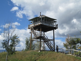
 We
spent an hour or so on the grounds of Fort Missoula. There was a
small shack outside a shortened, historic fire watch tower, and
inside was a
small exhibit on the history of fire watch towers - which was
surprisingly interesting. I didn't know that fire watch tires were
sold and shipped as kits! Then we went up the restored watch tower,
moved from elsewhere. I've always wanted to go up a fire watch
tower. You can't go inside, but you
can see inside. It has lots of vintage instruments and even
vintage food and supplies. But when I saw the vintage
National Forest Service porcelain plates, I LOST MY MIND. I
WANT THEM. GIVE THEM TO ME. A search of the Interwebs when I got
back found NONE for sale ANYWHERE. That freakin' museum better have
replicas available in the gift shop someday...
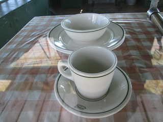
We
spent an hour or so on the grounds of Fort Missoula. There was a
small shack outside a shortened, historic fire watch tower, and
inside was a
small exhibit on the history of fire watch towers - which was
surprisingly interesting. I didn't know that fire watch tires were
sold and shipped as kits! Then we went up the restored watch tower,
moved from elsewhere. I've always wanted to go up a fire watch
tower. You can't go inside, but you
can see inside. It has lots of vintage instruments and even
vintage food and supplies. But when I saw the vintage
National Forest Service porcelain plates, I LOST MY MIND. I
WANT THEM. GIVE THEM TO ME. A search of the Interwebs when I got
back found NONE for sale ANYWHERE. That freakin' museum better have
replicas available in the gift shop someday...
The other thing I want is the
library train car on display. The Anaconda Copper Mining
Company lumber department’s library car served as an early
bookmobile for loggers in camps throughout Missoula County from 1921
to the late 1950s. After serving as a dormitory and storage shed at
the Lubrecht Experimental forest, it was brought to Fort Missoula in
2005. Today it houses an exhibit about the Lumberman’s Library. I
want one in my back yard. More info about this wonderful creation here.
The volunteers at Fort Missoula had told us about the Smoke
Jumper's Visitor's Center, which is at the airport. Stefan
said we were going to have to get on Interstate 90 next to the
airport anyway, so we might as well go. He didn't seem all that
enthused to go. We got there and the tour had just left, and
wouldn't be back for an hour. The center was otherwise all closed up
and we couldn't see any of the exhibits. So he harumphed, took
some photos, and we left. FYI, if you take the tour, you get
to see inside the
parachute loft and training facilities.
Then we got on Interstate 90, which we would be on for a few hours
at least to get back into Idaho. Ugh ugh ugh. I hate the Interstate.
Even if I went the 80 mph speed limit, it wouldn't have been fast
enough for most people. Luckily, traffic was much lighter than I
expected. We stopped for lunch in tiny, tiny Alberton, Montana,
having a very satisfying meal in a small cafe. And as Steve Earle
blared from the kitchen, I thought, "Yeah, you've got no problem
with Steve Earle, but I bet you hate the Dixie Chicks." If you don't
see the sexism in that whole controversy from way back then, you
really are willfully blind.
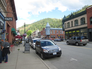 Stefan
had suggested we stop at Wallace, Idaho, for our final effort to see
something in association with the Big Burn of 1910, and so we did -
and that picturesque, historic town was HOPPING. They were having
their annual flea market, and the town felt like it was flourishing.
I loved it immediately. We parked on the street and I went into an
outdoor supply store to ask if there was a museum in town - there
is, the Wallace
District Mining Museum, right around the corner from where we
were. It was 4:30 and we power walked around the block. The museum
logo is awesome, celebrating firefighting. The museum staff found me
so amusing that they let us in for free!
Stefan
had suggested we stop at Wallace, Idaho, for our final effort to see
something in association with the Big Burn of 1910, and so we did -
and that picturesque, historic town was HOPPING. They were having
their annual flea market, and the town felt like it was flourishing.
I loved it immediately. We parked on the street and I went into an
outdoor supply store to ask if there was a museum in town - there
is, the Wallace
District Mining Museum, right around the corner from where we
were. It was 4:30 and we power walked around the block. The museum
logo is awesome, celebrating firefighting. The museum staff found me
so amusing that they let us in for free!
The museum is small, but worth a visit. No, they don't have much
about the Big Burn
of 1910, but what they have is interesting: what is probably the
prototype for the Pulaski firefighting tool, and a binder of
old photos and information about the Big Burn. In case you don't
know (I didn't until the PBS special), the Great Fire of 1910, also
commonly referred to as the Big Burn, was a wildfire that burned
about three million acres, approximately the size of Connecticut, in
northeast Washington, northern Idaho (the panhandle), and western
Montana. The firestorm killed 87 people, mostly firefighters, and it
is believed to be the largest, although not the deadliest, forest
fire in USA history. The aftermath of the fire highlighted
firefighters as public heroes and raised public awareness
surrounding nature conservation. The most famous story from the fire
is probably that of Ed Pulaski, a U.S. Forest Service ranger who led
a large group of his men to safety in an abandoned prospect mine
outside of Wallace, just as they were about to be overtaken by the
fire. At one point, one of the men announced that he was getting out
of there. Afraid others would follow him, and knowing that they
would have no chance of survival if they ran, Pulaski drew his
pistol, threatening to shoot the first person who tried to leave. In
the end, all but five of the men survived. The mine entrance, now
known as the Pulaski Tunnel, is listed on the National Register of
Historic Places. Pulaski is widely credited for the invention of the
Pulaski hand tool, still commonly used in wildland firefighting and
now called a "Pulaski tool".
 The
museum notes that the 1997 film Dante's Peak was shot on
location in Wallace, with a large hill just southeast of the town
digitally altered to look like a volcano. Heaven's Gate was
partly filmed there as well. Lana Turner is from there. The museum
has a lot of mining tools on display, as well as other items from
the boom times, like a
massive bank safe and this
torture device.
The
museum notes that the 1997 film Dante's Peak was shot on
location in Wallace, with a large hill just southeast of the town
digitally altered to look like a volcano. Heaven's Gate was
partly filmed there as well. Lana Turner is from there. The museum
has a lot of mining tools on display, as well as other items from
the boom times, like a
massive bank safe and this
torture device.
Yes, Wallace
really does have a bordello museum. It also has a
brewery, and we bought a six pack of the beer from the local
grocery store. We also found
this hilarious door sign. Had there been a place to stay in
town, we might have that night. Later, I found that, in 2004, the
town proclaimed itself the "Probalistic Center of the Universe,"
marked by a sewer access cover at the intersection of Bank Street
and Sixth Street. It was declared in a public celebration to poke
fun the Coeur
d'Alene Basin Record of Decision, something having to do with
Lake Coeur d'Alene, the Coeur d'Alene tribe, the EPA, the EPA's Superfund,
and who knows what else - I tried for 30 minutes to figure it out,
but never could.
We pushed on, hoping for national park camping, but it was getting
late, and our prospects were fading. We ended up at a
campsite right on the Coeur d'Alene river and right next to
I90. I'm not going to say the name because it wasn't so great: there
are no designated sites for tents, only the first three or so tent
campers get a picnic table (or something kinda resembling such), and
the bathrooms stunk badly on the outside from a leaking septic tank.
Plus, I watched the campsite owners' dog take a big dump in the
campgrounds and then run back to the house - no one cleaned it up.
The only good things from the evening: (1) we had a camp site before
dark on the Saturday night of Labor Day weekend and (2) the
1910 Black Lager from Wallace Brewing Company was delicious.
Sunday, Day 10
Bad news in the night: the zipper on the outer door of our tent
broke. It no longer keeps the zippered parts together. We could
still use the inside mesh door, which keeps bugs out, but the outer
door keeps the tent surprisingly warmer on cold nights. And we were
in cold weather now during the night. The tent, bought from Aldi
grocery store in Germany, about 10 years ago, is beloved by both of
us: a three-person tent, which means it has plenty of room for our
stuff and us inside, plus it has a large vestibule on the rain fly,
allowing us to keep stuff outside the main part of the tent but it
will stay try. And the rain fly can come off for dry, hot nights,
but the mesh on the inner tent isn't entirely see-thru, unlike
modern tents. WE LOVE THIS TENT SO MUCH. Unless we can come up with
an easy repair, the tent is done after this trip. Sad face.
Good news: other campers that were leaving brought us hot coffee. It
was so good. I also cooked a big breakfast, my first since our first
morning out. We were out by 10:15, barrelling down I30, and exiting
for Lake Coeur d'Alene.
The drive around Lake Coeur d'Alene is an official Idaho scenic
bypass. It's a nice drive, but you don't see the lake much, and
there are few opportunities to park and look at it. It's not an easy
ride - lots of steep inclines and sharp turns. Luckily, there was
very little traffic. That was shocking, as it was Labor Day weekend,
and the lake is thickly populated with ultra nice houses...
mansions... castles. Big wealth around that lake. We
finally found a place to pull off and look at the lake.
We continued South, on state road 3, then 6, then 9, through Harvard
and Stanford and near Princeton (ja, rly), and then stopped for a
very good lunch at Big Racks Barbecue in tiny Deary, Idaho. But had
we known at the time, we would have stopped at Firefighters' Circle
at Woodlawn Cemetery in St.
Maries, Idaho along the way. 57 men who died fighting the
1910 fire are buried there, in addition to other FS firefighters who
died fighting fires in later years. The memorial is on the National
Register of Historic Places, and may be the only federally-owned
cemetery plot that has nothing to do with the military. Here is a list of
all known burial places of firefighters who died fighting the Big
Burn.
Not sure if it was before or after Deary, but we saw some
firefighter trucks going in the opposite direction of us, trucks
that service encampments of forest firefighters. Shortly thereafter,
on the left side of the road, we
saw such an encampment. It was our impression that the
encampment was closing. It looked like that, just a few days ago, it
had been HUGE, and on both sides of the road.
The drive south, on the
White Pine Scenic Byway, was lovely, and I noticed that
between the small towns of Kendrick and Juliaetta, there was a paved
bike trail. It's more than five miles long, and is a former Northern
Pacific Railway line. I was so jealous! My dream is for a bike trail
from Atkinson Park in Henderson, Kentucky, across a pedestrian and
bicycle bridge across highway 41 that descends into the old Big K
parking lot, goes along Barrett Boulevard, then goes along highway
60 all the way to the bridge over the Green River in Spottsville. It
would be 10 miles long. Bike trails revitalize small communities -
just look at what the
bike trail did for Vernonia, Oregon!
 We
went around Lewiston on 95 South and stopped at the Nez Perce
National Historical Park Visitor Center. The ranger was
talking to other visitors, and was on a tirade about the treaties
the USA government has broken again and again, and the
ever-shrinking Nez Perce lands. He was so passionate - it was a
great talk! We picked up a brochure and noticed it said something
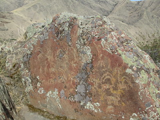
about petroglyphs. The ranger raved about them, and I got the
impression they were quite close, so off we schlepped in the heat to
see them. Welp, it takes well more than an hour to get there and see
them. I'm glad we did - the drive through Lewiston was a big pain in
the ass, but the drive along the Snake River to the petroglyhs was
lovely. And the petroglyphs are plentiful. There
are some really beautiful images. The tribe no longer allows
the images to be reproduced on t-shirts or other products, so you
aren't going to see these everywhere the way you see Kokopelli. Are
the images sacred? It depends on how you define sacred. They may or
may not have been religious. They were most definitely expressions
of what people were seeing, experiencing and dreaming of.
We
went around Lewiston on 95 South and stopped at the Nez Perce
National Historical Park Visitor Center. The ranger was
talking to other visitors, and was on a tirade about the treaties
the USA government has broken again and again, and the
ever-shrinking Nez Perce lands. He was so passionate - it was a
great talk! We picked up a brochure and noticed it said something
about petroglyphs. The ranger raved about them, and I got the
impression they were quite close, so off we schlepped in the heat to
see them. Welp, it takes well more than an hour to get there and see
them. I'm glad we did - the drive through Lewiston was a big pain in
the ass, but the drive along the Snake River to the petroglyhs was
lovely. And the petroglyphs are plentiful. There
are some really beautiful images. The tribe no longer allows
the images to be reproduced on t-shirts or other products, so you
aren't going to see these everywhere the way you see Kokopelli. Are
the images sacred? It depends on how you define sacred. They may or
may not have been religious. They were most definitely expressions
of what people were seeing, experiencing and dreaming of.
We went back towards Lewiston, stopping at a gas station to gas up
as we continued to gas up, and a biker pulled in on a BMW. And,
unbelievably, it was snobby snearing biker woman. We were stunned.
And didn't speak to her - just looked at each other incredulously.
What are the odds we would end up at a gas station well off the
beaten path at the SAME TIME? She had a Montana license plate, so I
was pretty sure she would be taking 12 East and heading back home
and we wouldn't have to see her snide face anymore.
We headed South on 95, through the Nez Perce reservation, and I was
nervous. Where would we stay that night? It was Sunday, still a
holiday weekend. I thought our odds were good - but you just never
know. About an hour later, I saw a sign for Winchester State Park,
and I took it. I seriously doubted they would have any camp sites
available, but I knew it was probably our only chance for a long
while. Holy cow, there were places available! We got a great
campsite in the lesser camp sites which don't have flush toilets,
near the yurts. Most of the other campers were in RVs, and loved
running their generators (ugh). Someone had left their camp site and
left a lot of wood, so Stefan cobbled together a camp fire for the
night. We really needed it - it was cold, though not freezing. We
passed many signs that said the fire danger was "high" or "extremely
high", yet, we only went to one camp site where fires were
forbidden. We could see the lake at the bottom of the hill below the
campsite. I walked back to the closed visitor's center to pay for
our camping, and as usual, people tried to pay me the entrance fee
as they came in, even though I didn't have a safety vest on. I could
make so much money! A loud group of campers were singing nearby -
Stefan thought they were a juvenile offender group, but I thought
they were a church group. Yeah, it is easy to confuse the two. I was
so tired, and could have gone to bed at 8:30, but I stayed up,
determined not to go to bed before the two young girls at the camp
site next door.
Oh, mensch, I was SO glad to be in this campsite. We were so lucky
there were openings!
Monday, Day 11
Happy Labor Day! I expected campers to start leaving super early,
but most seemed in no hurry at all to leave. We walked down to the
lake, which is pretty, but nothing particularly special. We went
to the visitor's center, now open, just to see inside. There was a
wolf rescue center nearby, and I asked about it. She said that
they are down to just two wolves at the sanctuary, and I decided I
really didn't want to disturb them. We packed up and left later
than usual.
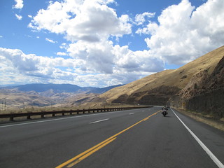 95
South had this incredible, dramatic, steep decline, and it was
terrifying and exhilarating, all at the same time. I was so
thankful for the semi truck in front of me, which had to go as
slow as I really wanted to go, so the long line of cars behind us
blamed him, not me, for the slow down. I'd read online that 95 was
a really nice drive, but based on our earlier experience, riding
it from Cambridge, Idaho to Jordan Valley, Oregon, I had given up
hope for it. But to Cambridge, it's LOVELY.
95
South had this incredible, dramatic, steep decline, and it was
terrifying and exhilarating, all at the same time. I was so
thankful for the semi truck in front of me, which had to go as
slow as I really wanted to go, so the long line of cars behind us
blamed him, not me, for the slow down. I'd read online that 95 was
a really nice drive, but based on our earlier experience, riding
it from Cambridge, Idaho to Jordan Valley, Oregon, I had given up
hope for it. But to Cambridge, it's LOVELY.
Just as the very intense ride down into a canyon on 95 was
getting not so scary, I saw a sign that said "Picnic table ahead."
It turned out to be much more than that: it was the Skookumchuck
Recreation Site, a grassy, shady area with picnic tables, changing
rooms and pit toilets, all
next to beautiful white sands on the Lower Salmon River. Had
it been hotter, we would have finally used those bathing suits we
brought. We so would have loved to have come to this site the week
before!
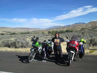
Before Cambridge, we stopped in Riggins for lunch. Riggins clings
to the side of a canyon, and I was super scared I would be having
to make some crazy turn into or out of a restaurant, into or from
a slanted parking lot. That didn't happen. What did happen was
seeing a KLR, just like mine, passing in the opposite direction as
we had lunch. It always seem likes motorcycles are going in the
opposite direction as us. I don't mean while we're riding, I mean
when we stop for a rest or for lunch. Also, we saw a LOT of KTMs
this trip, probably more than we saw BMWs - that's never happened
before.
We had a cloud burst - the rain looked so intense up ahead that
we pulled over and put on all our rain gear. But we were through
it really in just a few minutes, and it wasn't going our way on
the road, so we stripped it all off at a gas station soon after.
It has started to get windy, and I could see dust devils ahead,
but the wind, while annoying, was mostly constant, rather than
gusting, so I did just fine.
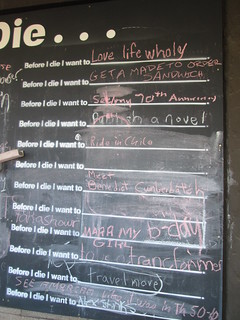 And
then we were back in Cambridge, where we'd been on day 3 of our
trip. Just like then, there was a regular parade of motorcyclists
through the town. What we didn't see on that first visit, but saw
this time, was a
giant chalk board outside the grocery store that said
"Before I die, I want to..." and had slots for 24 people to
respond. You can probably find my Stefan's entry ("Ride in Chile")
and mine ("Meet Benedict Cumberbatch"). I carefully erased a giant
penis someone had written on the board before we wrote our
entries.
And
then we were back in Cambridge, where we'd been on day 3 of our
trip. Just like then, there was a regular parade of motorcyclists
through the town. What we didn't see on that first visit, but saw
this time, was a
giant chalk board outside the grocery store that said
"Before I die, I want to..." and had slots for 24 people to
respond. You can probably find my Stefan's entry ("Ride in Chile")
and mine ("Meet Benedict Cumberbatch"). I carefully erased a giant
penis someone had written on the board before we wrote our
entries.
 Then
it was back the way we'd come a week before, now in the opposite
direction: back to Hell's Canyon, back over Oxbow dam,
to Copperfield Park campground. I was super nervous about the
ride, but did just fine, even keeping it together when a guy came
around a corner somewhat in my lane. The hill after the dam didn't
seem nearly as steep as it had before. But an uphill 20 mph curve
framed by sheer rock just before Oxbow really bothered me - I
can't imagine making that turn if a big RV or truck had been
coming from the other direction.
Then
it was back the way we'd come a week before, now in the opposite
direction: back to Hell's Canyon, back over Oxbow dam,
to Copperfield Park campground. I was super nervous about the
ride, but did just fine, even keeping it together when a guy came
around a corner somewhat in my lane. The hill after the dam didn't
seem nearly as steep as it had before. But an uphill 20 mph curve
framed by sheer rock just before Oxbow really bothered me - I
can't imagine making that turn if a big RV or truck had been
coming from the other direction.
Copperfield Park campground was more than half empty now, but
looked like it had been used absolutely every night since we left
- the tent area grass looked like it might never recover. We
camped in the same place we had more than a week before, and I
walked around looking for leftover fire wood in fire pits. Since
it was Labor Day, I was sure there would be plenty. But there was
barely any at all - someone had already raided the fire pits. As
there was only one other set of tent campers at that point, and
they had only full, unburned wood stacked and ready to burn, I
knew it was one of the RV folks, and it made me mad. We can't
carry wood on the bikes, at least not easily, but they can carry
wood super easily. No wood was for sale at our camp site. Damn it!
Still, we ended up somehow putting together a fire with what we
could find. We each took much-needed showers, and watched the far
nicer campground host, someone different than when we were there
before, helping a group put up a tent.
Tuesday, Day 12
We changed our watches the night before back to Oregon time, and
were leaving at 10:30, which meant we were actually leaving an hour
later than we ever had. But we obviously needed that sleep. We
headed out on state road 86, turning off on National Forest road 39
for the Hell's Canyon Overlook. The road was much more difficult
than I was expecting - VERY curvy and steep. By the time we got to
the turnoff for the overlook, I almost bagged out. I was afraid it
would be even more difficult. But I dug deep and did it anyway, and
it turned out to be the easiest part of the entire ride.
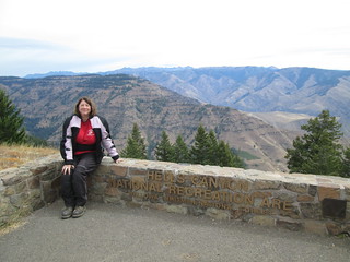 It
was cloudy, but the view from the Hell's Canyon Overlook was still
splendid. Sadly, the pit toilets were not so great - obviously not
serviced since the Labor Day weekend, and obviously used by people
with not much respect for public lands. There was a guy there on a
xxx motorcycle, not at all meant for long-distance travel, but there
he was, going across country. I really admire people like that.
Unfortunately, he had a slow leak in the back tire, and I insisted
we wait until he had pumped it up and used fix a flat and left
himself before we left. While we were waiting, some guy gave me a
bag of watermelon. Not sure how I looked as though I needed
watermelon, but clearly, I did.
It
was cloudy, but the view from the Hell's Canyon Overlook was still
splendid. Sadly, the pit toilets were not so great - obviously not
serviced since the Labor Day weekend, and obviously used by people
with not much respect for public lands. There was a guy there on a
xxx motorcycle, not at all meant for long-distance travel, but there
he was, going across country. I really admire people like that.
Unfortunately, he had a slow leak in the back tire, and I insisted
we wait until he had pumped it up and used fix a flat and left
himself before we left. While we were waiting, some guy gave me a
bag of watermelon. Not sure how I looked as though I needed
watermelon, but clearly, I did.
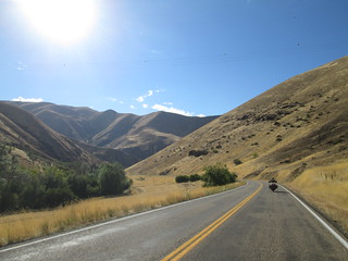
We headed back down on road 39, towards Joseph. And upon arriving -
what a charming town! We'd never been before. It's a town where
there is Western art for sale, where there are bistros and down home
cafes, and where tourists and ranchers come. We ate at a corner cafe
and, as it served breakfast all day, yes, oh yes, I once again had
biscuits and gravy. Then we took a stroll through town. I would love
to come back to Joseph! But we never saw any places to stay in
Joseph. The interwebs says there are three places, but I'm
skeptical.
On our way back to La Grande, there was a little rain, but not
enough to need rain gear, and a little wind, but it was constant
rather than gusts, and not too bad. Still, it was cold, and the
night would probably be quite cold. So we decided to hotel it one
more time. We went away from the interstate, where I knew the hotels
would be $100 a night, at least, to the Orchard
Motel farther in town. It was half the price. We really
appreciated the owner putting us in the room right next to the
office, so that our motorcycles could be parked with an obstructed
view from the street. I got caught up in several episodes of Parks
and Rec, and kept waiting for Stefan to go out to the nearby
Safeway and get beer, but apparently he was waiting for me to go
with him, and we ended up not going anywhere. Communication!
I ate at least half of the sweet, sweet watermelon I was gifted
earlier...
Wednesday, Day 14
There was a place to get breakfast right next door, so we walked
over. And guess what I had. GUESS WHAT I HAD.
We walked over to Safeway and got bread, then packed up and headed
out. We got on 84 West very briefly, then got off on state road 244,
and the
ride was lovely, quite an unexpected delight. And
there was a vast amount of camping everywhere. At first I regretted
that we'd stayed in a hotel that night, but I talked to some hunters
that camped and they said it had rained a LOT the night before, and
that it was quite cold, so I changed my mind. Added bonus: I saw a
coyote in a farm field, watching us drive by. He was beautiful...
but I started to see something I didn't see much of at all in Idaho:
junky homesteads. On backroads in Oregon, we see a lot of shacks,
old trailers and falling-down houses surrounded by junk. It's sad.
 We turned South on 395, and had lunch in
Long
Pine, then pushed on to Mitchell, which seems to have fallen
on harder times than when we stopped here for supplies a few years
ago - more businesses were for sale or closed. We did see an awesome
retro-style poster for eclipse viewing in August 2017 in the Painted
Hills of John Day National Monument. That would be so awesome.
We turned South on 395, and had lunch in
Long
Pine, then pushed on to Mitchell, which seems to have fallen
on harder times than when we stopped here for supplies a few years
ago - more businesses were for sale or closed. We did see an awesome
retro-style poster for eclipse viewing in August 2017 in the Painted
Hills of John Day National Monument. That would be so awesome.
 And
speaking of the Painted Hills, that was our goal for the evening.
We'd been to Sheep Rock Unit and the Thomas Condon Paleontology
Center before, as well as the Kam Wah Chung & Company Museum, so
we skipped it this trip. We stopped at an overlook of the John Day
monument we'd stopped off years before, then we turned off Highway
26 to the Painted Hills.
And
speaking of the Painted Hills, that was our goal for the evening.
We'd been to Sheep Rock Unit and the Thomas Condon Paleontology
Center before, as well as the Kam Wah Chung & Company Museum, so
we skipped it this trip. We stopped at an overlook of the John Day
monument we'd stopped off years before, then we turned off Highway
26 to the Painted Hills.
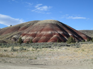
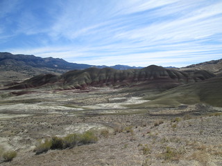
I've no idea how or why it's taken us so long to visit it. There's
abundance of fossil remains of early horses, camels, and
rhinoceroses in the Painted Hills, which get their name from the
delicately colored stratifications in the soil-yellows, golds,
blacks and reds. And in the late afternoon, the hills were quite
beautiful. If you can, you do want to see them at different times of
day, because the colors really do change. And when those hills are
red, they are RED. It's gorgeous.
We went to the Painted Hills information center, to see what there
was to see - we knew that if it was staffed, it was already closed.
While we were there, a site worker came by to get something from
inside, and per our comment about looking for camping with a pit
toilet, he suggested we camp at Priest Hole, about seven miles away.
He said the road was as easy as the gravel outside the information
center.
 He
was mostly right about the road: it was easy until the last two
miles. Then, at the turnoff for the campground, the road was narrow,
single lane, with few places to pull over if another car was coming,
steeply downhill, with huge dips marked with 10 mph signs, big
gravel pieces, and big rocks in the pathway. It was one of the most
difficult roads I'd ever done. I was terrified. If I fell this time,
it would hurt me AND the bike. I was terrified all the way to the
camp site parking lot.
He
was mostly right about the road: it was easy until the last two
miles. Then, at the turnoff for the campground, the road was narrow,
single lane, with few places to pull over if another car was coming,
steeply downhill, with huge dips marked with 10 mph signs, big
gravel pieces, and big rocks in the pathway. It was one of the most
difficult roads I'd ever done. I was terrified. If I fell this time,
it would hurt me AND the bike. I was terrified all the way to the
camp site parking lot.
I don't remember parking the bike. I don't remember getting off my
bike. I do remember Stefan, instead of saying, "Good job!" or "Wow,
what a hard road!" started telling me how I was too careful and
should have just gone faster. I stripped off my jacket and gloves
and walked away to the shoreline of the John Day River, sat down and
tried not to burst into tears. I don't know how long I sat there,
but once Stefan got the tent up, I laid out the Thermarests, letting
them self inflate, and I laid down on the tent floor off to the side
and tried to calm down. I was there for an hour.
I'm sure some readers are laughing. It sounds absurd. But it really
was terrifying. It's just not something any of you that grew up
riding dirt bikes, or that have been riding off road for years, or
that are tall, can ever understand. Also, I'm 50 years old, and if I
break something, it will never heal, not really. That is a really,
really scary thought. It doesn't keep me from getting out and doing
things, but it's there, in the back of my mind. And for those who
think, well if you are so scared, why do you keep riding?
(1) I enjoy it far, far more of the time, (2) I'm much more scared
on my bicycle, and (3) I fell walking Lucinda and Jaxson four weeks
ago and a part of my stomach where I hit the ground was so bruised,
it was almost black - so should I give up walking dogs?
 I
gradually recovered, and we sat on the panniers, drank beer and
talked about how it really wasn't that pretty at Priest Hole. It
wasn't ugly, but, really, it wasn't all that scenic. We could tell
that, at other times, it must be WAY crowded. And no way would I get
in the John Day River - it was full of moss and looked disgusting.
People swim here? NO WAY.
I
gradually recovered, and we sat on the panniers, drank beer and
talked about how it really wasn't that pretty at Priest Hole. It
wasn't ugly, but, really, it wasn't all that scenic. We could tell
that, at other times, it must be WAY crowded. And no way would I get
in the John Day River - it was full of moss and looked disgusting.
People swim here? NO WAY.
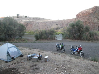
There are no designated campsites and no fire pits at this site, and
probably not any others - you just find an area that looks decent
and stop. We were shocked at how many campers there were - we'd
thought we'd have the place to ourselves. I'm not really
complaining: it was clean and it was free and it was quiet.
The stars were, once again, lovely. We didn't put on the rain fly -
it was so hot, with no chance of rain, there was no need.
Sadly, in addition to losing my cool, Stefan also lost the rest of
the watermelon - it wouldn't fit in the cooler with the beer, so
he'd tried to strap it to a bag. The gravel had knocked it lose and
off. I had really been looking forward to that for dinner...
Thursday, Day 15
Stefan's 45th birthday. I dug deep and tried so hard to be nice, but
I was still so hurt by his comments the day before. And I was so
dreading the way out of this camp site, I could barely eat
breakfast. I told Stefan what I had been thinking all morning: I
can't tour Chilé by motorcycle. I can't do 50 miles of gravel a day,
let alone the 100 or so that would be required on some days, from
what I've heard. The “carretera Austral” that leads to the Patagonia
and Tierra de Fuego is mostly gravel. And to think I was mostly
worried about the strong winds in Patagonia. I hate giving up that
dream, but I guess I'm going to have to. What a lousy birthday
present.
 Stefan
moved my bike for an easier line to the drive way that lead out of
the camp sites and up to the parking lot. We mounted up, I road out,
I road up the hill, faster than I normally would because of what
Stefan had said the night before, I lost control at the top and I
went right off the road and into sand. I stopped, managing to not
fall over, and tried not to cry. Stefan came over, held the bike
while I got off, and moved my bike back on the road and up to the
parking lot. As I walked up to the bike, humiliated and terrified,
he put his hand on my shoulder and said, "You can do this, you can."
I didn't believe him, but really appreciated this different
attitude. I sat on my bike for a moment, and thought, you know, I've
gotten through awful gravel scenarios my own way, and with one
exception - the right hand hair pin single lane turn uphill at
Schafer Switchbacks, I'd made it okay, with just one minor fall on
the way to Silver City that even Stefan said couldn't have been
avoided. Screw this, I'm doing this road my way. So I did. As it was
now mostly an uphill road, so it was a lot easier, and I did go a
lot faster than I did when I went downhill, but that's how I usually
do uphill.
Stefan
moved my bike for an easier line to the drive way that lead out of
the camp sites and up to the parking lot. We mounted up, I road out,
I road up the hill, faster than I normally would because of what
Stefan had said the night before, I lost control at the top and I
went right off the road and into sand. I stopped, managing to not
fall over, and tried not to cry. Stefan came over, held the bike
while I got off, and moved my bike back on the road and up to the
parking lot. As I walked up to the bike, humiliated and terrified,
he put his hand on my shoulder and said, "You can do this, you can."
I didn't believe him, but really appreciated this different
attitude. I sat on my bike for a moment, and thought, you know, I've
gotten through awful gravel scenarios my own way, and with one
exception - the right hand hair pin single lane turn uphill at
Schafer Switchbacks, I'd made it okay, with just one minor fall on
the way to Silver City that even Stefan said couldn't have been
avoided. Screw this, I'm doing this road my way. So I did. As it was
now mostly an uphill road, so it was a lot easier, and I did go a
lot faster than I did when I went downhill, but that's how I usually
do uphill.
We went back to the Painted
Hills information center, and I felt more lucky than
triumphant. I told Stefan to go to the
Painted Hills overlook on his own, I was going to stay behind
and just gather my thoughts. It was nice to be alone for a bit and
just think and make notes in my travel journal, but what was weird:
no one who came to the information center spoke to me. Usually, with
Stefan, people walk up and chat. Alone, no one did. Did I look like
a scary biker chick?!
I was thinking about the trip, how we'd successfully avoided all
talk of politics with anyone at all the entire time, and how we'd
seen only three presidential signs - two for Trump and one for
Hillary. That's it. In all of Idaho. Other than local race signs,
you would never know an election was approaching. And the biggest
shock of all: no anti-United Nations signs. Not one. In Oregon,
there are three within 10 miles of our house. What did it
mean?
Stefan returned, and we went on 26 to Prineville, which we've done a
few times before, but I never have any memory of until we get to
Prineville. We stopped for lunch at TasteeTreat, and I was
fascinated by two hunters that pulled up in a pick up truck pulling
a big trailer packed with stuff, like a massive cooler - far bigger
than the one we have in the garage, lots of things covered with
tarp, and cornhole boards. I was one of only two women customers
there. Most of the men were in camouflage, there was a table forest
firefighters, and there was us, the biker couple. I guess I should
be more concerned with what I eat... I don't eat this way when I'm
not on vacation. But, dang, fried food is so delicious.
 We
continued North on 26, seeing
some huge smoke plumes in the distance. We stopped in Madras.
Stefan was convinced there was an ice cream parlor there. I had no
memory of it. I had no memory of ever stopping in Madras. I had no
memory of Madras. What an ugly town. Sorry, Madras. And the wind was
blowing more and more. After a lot of driving around and a surge in
frustration, he realized he was thinking of another town. So we went
to the Black Bear Diner, which I knew just had to have ice cream and
pie. Even better: they had milkshakes. Stefan went out to his bike
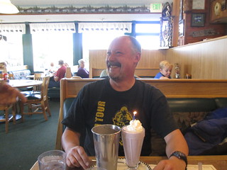
to get his camera, and while he was gone, I told the waiter it was
Stefan's birthday. So he brought a candle, stuck it in Stefan's
whipped cream on the milkshake, lit it, and he and another guy sang
to him. It was HILARIOUS.
We
continued North on 26, seeing
some huge smoke plumes in the distance. We stopped in Madras.
Stefan was convinced there was an ice cream parlor there. I had no
memory of it. I had no memory of ever stopping in Madras. I had no
memory of Madras. What an ugly town. Sorry, Madras. And the wind was
blowing more and more. After a lot of driving around and a surge in
frustration, he realized he was thinking of another town. So we went
to the Black Bear Diner, which I knew just had to have ice cream and
pie. Even better: they had milkshakes. Stefan went out to his bike
to get his camera, and while he was gone, I told the waiter it was
Stefan's birthday. So he brought a candle, stuck it in Stefan's
whipped cream on the milkshake, lit it, and he and another guy sang
to him. It was HILARIOUS.
We left the diner, stopped at Safeway, and continued North. It
was beautiful at times, but NOT a pleasant ride: it was windy,
and one gust almost threw me right off the bike (Stefan too!). There
was a TON of traffic, all going way over the speed limit. We stopped
at a liquor store just before Warm Springs, and I had trouble
holding my bike up because of the wind while I waited for Stefan to
get beer, ice and cigarettes. We went through Warm Springs Indian
Reservation, passing the packed casino parking lot, and climbed up
through the hills, with a growing number of cars and trucks behind
me because I was going the speed limit. There was rarely a place to
pull over, something I like to do every 50 miles or so. At last, I
saw a sign for a "chain up" area, and though, I don't care if we are
going uphill, I'm going to somehow stop there. And I did. After our
break, we somehow also got a break in traffic, and were able to ride
with no one behind us.
Our target for the night was Mt. Hood National Forest. We could have
driven all the way home on this day, but I really didn't want to get
home early, despite missing Lucinda and Gray Max. Plus, we had never
camped in in Mt. Hood NF - we've driven through many times, but
since it was so close to our home in Canby, and we wanted to camp
farther away, plus that it was always PACKED with campers, we never
bothered. We had planned on camping at Timothy Lake, but I turned
off at Little
Crater Lake campground instead, and I'm glad I did; it was
booked solid for the weekend, but was mostly empty that night. It
also would be closing after that weekend. Stefan pulled into a camp
site, I stayed on the road, waiting for him to park and then I would
go in next to him, I looked over at something else, and when I
looked back, Stefan had fallen over! THIS NEVER HAPPENS. He thought
the ground was flat where it wasn't, and when he put the kick stand
and his foot down, there wasn't enough there to hold it all up. I
parked, jumped off my bike and we righted his. I was scared but,
later, comforted: this really ain't easy for everyone.
Something about the camp site we picked wasn't sitting well with us.
So we did something we rarely do - we moved after starting to
unpack. Our
second campsite felt a little more open, and we hoped it would
get sun in the morning, because we could feel a VERY cold night
coming on. This time, we cobbled together a very hearty amount of
leftover firewood from other fire pits for a fire. After stacking
all the wood for later, we walked around the camp site and down the
Little Crater Lake trail, to what is actually a small
crystal clear, cold spring-fed pond. It is far deeper than it
looks in our photos, and oh-so-clear. It is considered a geologic
oddity, created by dissolving limestone. It is not of volcanic
origin. It remains near 34 degrees Fahrenheit year round. There are
some days early in our trip when I would have really loved to have
had this pond around... We walked further on the trail, to where it
meets the the Pacific Crest Trail. For those that don't: it's a
long-distance hiking and equestrian trail, 2,659 mi (4,279 km) long.
According to Wikipedia, most thru-hikers cover about 20 miles (32
km) per day. I would like to stand
at the trail crossing all day and bother... I mean, talk to...
the hikers that go by. As for hiking it myself: those days are
passed. I'm lucky that my knees still allow me to hike, but I doubt
I could carry a pack that long. What a shame there isn't a network
of European-style hostels all along this and the Appalachian
trail...
It was nice to be staying overnight in this national forest at long
last, but, wow, it's a perfect example of public lands being loved
to death. Everything was trampled. The land looked like it could
really use a rest for a long while from hikers and picnickers and
campers. When we've driven through on other occasions, not only are
the camp sites packed, but all sorts of places along the road have
campers tucked away. People are playing music loudly, children are
riding their bikes around, often through camp sites, there's quite a
bit of traffic... it doesn't feel like you're really getting away
from anything. I really hope Tillamook Forest never becomes that
way.
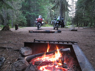 Stefan
made the fire, we drank our beer, I saw two does slowly making their
way through the campground, keeping their distance from us, and we
looked up at the stars through the trees. And I was so grateful to
be able to do this. Geesh but I'm lucky.
Stefan
made the fire, we drank our beer, I saw two does slowly making their
way through the campground, keeping their distance from us, and we
looked up at the stars through the trees. And I was so grateful to
be able to do this. Geesh but I'm lucky.
There were just three campers that came in after us, and I strongly
suspect one of them didn't pay. It was really expensive for a camp
site with just a pit toilet and a water pump a bit of a hike down
the road - for similar sites, we'd paid just $10, or nothing, and we
were paying $23 here. Still, I always pay, if there is a way
to pay. It's unethical and disrespectful otherwise. I would no more
not pay than I would shoplift. Maintaining a campsite, even a
primitive one, is expensive.
It was getting really cold, so cold that, for the first time, I used
my sleep sack inside my sleeping bag to stay warm. We had the rain
fly on, just to make the tent that much warmer, but as the door was
broken, we had only the screen on the door. Still, I was very
comfortable and cozy in that tent. In the middle of the night, we
were both awakened by two birds very nearby - in fact, I would say
they were right on our picnic table - having a conversation. They
almost sounded like monkeys! I thought they were owls at the time,
and after listening
to owl sounds online, I still do. Mensch but the were loud!
Friday, Day 16
All that riding caught up with us - along with the cold, we slept
hard and long. We did not get up until freakin' 9:30 a.m.! I
couldn't believe it. We'd never overslept before on the entire
trip, not even in hotels! The sun wasn't reaching our campsite, so
we were still super chilly. We had our last breakfast of the trip,
packed up, and headed out. We went by the campsites of Timothy
Lake, and they were packed. But I guess everyone else was sleeping
in too, because traffic was light. We were supposed to be taking a
gravel road Stefan said I'd done before, on my Honda Nighthawk
(not a dual sport!), years before, to 224 and then to Estacada. We
started out and there was a detour sign. We followed it and, ta
da, the gravel was NOT packed. Oh, I was pissed. I had wanted this
day to be EASY. To be FUN. And here was not-very-well-packed
gravel for me to struggle with. I actually did remarkably well -
because it was all slightly uphill and there was only one stupid
curve. But the detour signs were not always clear about where to
go. I ended up going the wrong way once we reached pavement, to a
lookout point we've been to many, many times before.
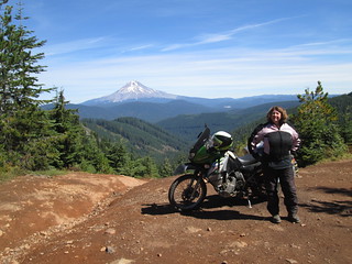
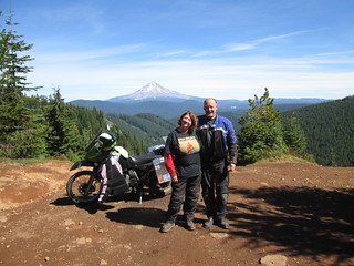 This
time, unlike those other times, I had Stefan move my bike into
position for photos of me and Mt. Hood, something he's done for
himself, but, for some reason, I never wanted to do before. Not
sure why. We met a guy at the lookout who does pyrotechnics with
the same company Stefan has trained with for the annual Forest
Grove July 4 fireworks. This guy also has done fireworks for Boise
on NYE, and he showed us photos on his phone of the giant potato
they drop at midnight. It seemed appropriate to be looking at a
photo of a giant potato, as the focus of our trip had been Idaho.
This
time, unlike those other times, I had Stefan move my bike into
position for photos of me and Mt. Hood, something he's done for
himself, but, for some reason, I never wanted to do before. Not
sure why. We met a guy at the lookout who does pyrotechnics with
the same company Stefan has trained with for the annual Forest
Grove July 4 fireworks. This guy also has done fireworks for Boise
on NYE, and he showed us photos on his phone of the giant potato
they drop at midnight. It seemed appropriate to be looking at a
photo of a giant potato, as the focus of our trip had been Idaho.
We went back on 224 and into Estacada, had pizza, got gas, and
headed home. I felt like the Jesus of Motorcycle travelers did not
want us to get home: we hit construction and had to wait in a long
line of traffic before we were allowed through, we got behind a
school bus, we had to take 205 for a while, which was horrible, a
stop light in Sherwood was broken, backing up traffic for a mile,
we got behind a cement truck, and traffic on Scholl's Ferry road
was nightmarish. Had we not overslept and had that stop light not
been broken and had traffic not been stupid, we would have been
home two hours earlier. But we rolled into the drive at 5. The
trip was over.
We went into the house, and our dog sitter's dog came bounding to
us, thrilled that we were home. Lucinda stood in the living room,
eying us suspiciously. But within 30 minutes, she was in the floor
with me, sitting on my lap. She did okay, not great: she got left
for 12 hours at one point, apparently, and chewed up some more of
my expensive Afghan carpet. Dang it! But she had done with the dog
sitters dog. Max was no where to be seen - he didn't come home for
three days more, disgusted that I wasn't home and dogs had overrun
the yard (he stayed over at Virgil's instead - we're practically
co-parenting these days).
By my estimation, I did well more than 120 miles of gravel on
this trip. To have done 10% gravel would have required 282 miles
of such. I would love to be so good as to do 10% gravel on every
trip. There were opportunities to get that additional gravel
mileage on the trip, but I passed on any gravel road that didn't
take me somewhere I really wanted to be. As I say elsewhere, I
know other riders take KLR motorcycles on dirt roads just a few
feet wide, straight uphill, covered in rocks. They stand in the
foot pegs. They wear helmet cams and make videos for YouTube. It's
a fearless bike, and most people that ride it are, apparently,
fearless. I'm not fearless. I'm a 50 year old woman who frequently
wonders what in the HELL am I doing. I have this bike for that 10
miles of gravel and dirt between me and a historic
old mining town. Or for touring City
of Rocks. I know that makes a lot of other dual sport riders
roll their eyes. Sometimes, the way I ride makes me feel unworthy
of this bike. I accepted long ago that I'll never be an expert
rider and that I have to ask for help sometimes. But I won't let
those limits keep me from riding. I'm much better on dirt and gravel than I was when I
started, and while I'm no Charlie Boorman (hi, Charlie!) - hey,
I've done okay. I've seen a lot of beautiful places because of
this bike, places most other people never will. She never lets me
down on those dirt and gravel roads I dare to do in pursuit of
some incredible place - when there's a failure, it's all mine. I
really do love this bike. She even has a name. No, I'm not going
to tell you - it's personal between her and me.
Fin
Know when I travel by:
Following me me at My
@jayne_a_broad Twitter
feed 
This Twitter feed is focused on my experiences traveling, camping,
riding my motorcycle or my bicycle, taking mass transit (buses and
trains), commuting by walking or bicycling, and various other
mostly-personal interests.
Liking my Jayne A
Broad Facebook page 
This Facebook fan page is where I follow USA state parks, national
parks, national forests, and organizations focused on sustainable
tourism, getting children, women and under-represented groups
outdoors, and related international organizations and sites. My
travel-related tweets from the my jayne_a_broad twitter feed
(see below) get posted here automatically.
Return to the broads abroad home
page
Disclaimer
Any activity incurs risk. The author assumes no responsibility for
the use of information contained within this document.
A Broad Abroad | contact me
The content of this page
is by by Jayne Cravens, 2006-2016, all rights reserved